|
Reported Crop Circles for the State of
Ohio -
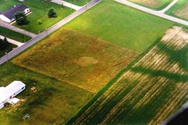
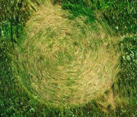
Sugar Creek Township / Elida, Allen County (August 1, 1996)
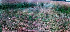
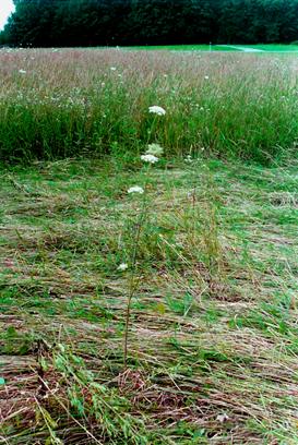
A 46.5 diameter circle with circling 1-3 pathways leading into and out of the circle curving around the field. The lay was counterclockwise, but not all the plants in the circle were affected / flattened, particularly a variety of Queen Annes Lace.
Spotted from the air by a pilot, the circle was located in a field between a soybean field and a residential neighborhood. When researchers arrived, no local residents were aware of the circles existence despite homes being within 100 yards of the circle. The circle could not be seen from the road. An underground stream ran directly underneath the circle. There were five power line poles on the west edge of the field within 50 of the circle; unusually, each power pole had a transformer box on it.
Three separate teams collected samples from this formation on three different dates. All three samples were reported to be consistent and had significantly lengthened stem nodes, node expansion as high as 167% greater than control samples, expulsion cavities, and the three sampling times showed that gravi-tropism was not a factor in contributing to node changes.
Two of the three teams that investigated this formation reported unusual physical effects to their persons after visiting the formation.
Crop type: Grass (Timothy)
Source: personal investigation, Roger Sugden, W.C. Levengood - Report #93
Photos: Roger Sugden, Jeffrey Wilson
|
|
City / County / Date:
- Middletown,
Butler County (1941)
- Carolton
(now Carrolton / Center Township), Carrol County (1960)
- Dellroy,
Carroll County (June 26, 1965)
- Gallipolis,
Gallia County (November 1966)
- Rush
County (1968)
- Meigs
County (1968)
- Columbus,
Franklin County (October 16, 1973)
- Mariemont,
Hamilton County (January 4, 1975)
- Lancaster,
Fairfield County (1977)
- Oak
Harbor, Ottawa County (1979)
- Helena,
Guernsey County (1986)
- Millersburg,
Holmes County (November 10, 1989)
- Millersburg,
Holmes County (February, 1991)
- Dundee,
Tuscarawas County (March 20, 1992)
- Austinberg
/ Ashtabula, Ashtabula County (August 30, 1992)
- Worthington,
Franklin County (April 1995)
- Paulding
/ Jackson Township, Paulding County (July 4, 1996)
- Sugar Creek Township / Elida, Allen County (August 1, 1996)
- Payne,
Paulding County
(June 27, 1997)
- Broughton
/ Latty Township, Paulding County (June 27, 1998)
- Lafayette,
Allen County
(June 1999)
- Bainbridge,
Ross County
(June 29, 2000)
- Careytown,
Highland County (June 24, 2002)
- Sardinia,
Brown County
(June 30, 2002)
- Locust
Grove, Adams County (August 24, 2003)
- Bourneville,
Ross County (September 6, 2003)
- Paint
Creek Island, Bainbridge, Ross County
(September 25, 2003)
- West
Union, Adams County (October 25, 2003)
- Cuba,
Clinton County
(June 15, 2004)
- Hillsboro,
Highland County
(July 5, 2004)
- West
Union, Adams County (August 16, 2004)
- Miamisburg,
Montgomery County (August 24, 2004)
- Rarden,
Scioto County (September 15, 2004)
- Patterson’s
Corner, Greene County (July 5, 2005)
- Yellow
Springs, Greene County (August 12, 2005)
- Fairfax,
Highland County
(April 21, 2006)
- Eagle
Township, Brown County (May 21, 2006)
- Newbury, Geauga
County
(July 7, 2006)
- Sandyville,
Tuscarawas County (July 22, 2006)
- Bucyrus, Crawford
County (August 31, 2006)
- Madisonburg,
Wayne County (September 1, 2007)
- Moscow, Clermont County
(June 6, 2010)
- Owensville, Clermont County (June 24, 2010)
- Chillicothe, Ross County
(Mid Sept 2012)
|


